
The best hikes in Seoul do not require leaving the city—or sacrificing an entire travel day.
Choosing one that matches your time and your legs is the harder part.
For a complete beginner, Achasan is the easiest place to start.
If you want the biggest visual reward in two or three hours, choose Inwangsan.
For something that feels more like a proper mountain hike, take the Samobawi–Bibong route in Bukhansan National Park—not the much tougher Baegundae summit route.
Korean hiking outfits can sometimes look ready for an expedition.
Your half-day Seoul hike does not necessarily need to.
Which Seoul Hike Should You Choose?
| Hike | Difficulty | Time | Subway Access | Best View | Best For |
|---|---|---|---|---|---|
| Inwangsan | Easy–Moderate | 2–2.5 hours | Line 3 Dongnimmun + walk | Central Seoul skyline | A short, scenic first hike |
| Achasan | Easy | 2–2.5 hours | Line 5 Achasan + 20–30 min walk | Han River and eastern Seoul | Complete beginners |
| Bukhansan: Samobawi–Bibong | Moderate | 3–3.5 hours | Line 3 Bulgwang + bus | Granite peaks and ridges | A real mountain experience |
| Bugaksan City Wall | Moderate | About 3 hours | Line 3 Gyeongbokgung + bus | Palaces, wall, and downtown | History with a workout |
| Ansan Jarak-gil | Easy | 2.5–3 hours | Line 3 Dongnimmun or Muakjae + walk | Inwangsan and Namsan skyline | A low-stress forest walk |
Times cover the recommended route at a normal sightseeing pace, not travel from your hotel. Weather, crowds, navigation, and photo stops can make any route longer.
Complete beginner: Achasan
Only have 2–3 hours: Inwangsan
Want central Seoul views: Inwangsan
Want a real mountain trail: Bukhansan Samobawi–Bibong
Want history with the hike: Bugaksan
Want the lowest-stress option: Ansan
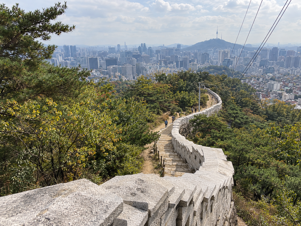
1. Inwangsan — A Short Hike With Big Central Seoul Views
Difficulty: Easy–Moderate
Time needed: About 2–2.5 hours
Distance: Roughly 3–4 km, depending on the exit route
Nearest subway: Dongnimmun Station, Line 3
Trailhead access: Exit 2, then walk toward Inwangsa Temple and Seonbawi
Best for: First-time visitors who want skyline views without losing half the day
Best season: Spring or autumn; clear winter days if the rock is dry
Gear: Grippy sneakers in dry weather; trail shoes in wet or cold conditions
Main drawback: Exposed stairs and granite can feel steeper than the short distance suggests
Start near Dongnimmun Station, pass Inwangsa Temple and Seonbawi, continue over Beombawi to the 339-meter summit, then descend toward Changuimun and Yoon Dong-ju Literary Museum.
This creates a point-to-point walk instead of repeating the same path.
The official Seonbawi section is 1.84 km one way and averages about 70 minutes to the summit.
Add the descent, navigation, and viewpoint stops, and two to two and a half hours is a more realistic estimate for most visitors.
You get granite slabs, the Seoul City Wall, and views toward Gyeongbokgung and Namsan.
For such a central mountain, the scenery changes surprisingly quickly once you start climbing.
The catch is exposure.
There is limited shade on the upper rock, toilets become scarce once you leave the lower area, and the final sections include narrow stairs and light rock scrambling.
After rain—or when winter ice is present—this is no longer the casual city walk the distance might suggest.
2. Achasan — The Easiest Place to Start
Difficulty: Easy
Time needed: About 2–2.5 hours including the station approach
Distance: Approximately 4 km for a simple out-and-back route
Nearest subway: Achasan Station, Line 5
Trailhead access: Exit 2, then walk uphill about 20–30 minutes to Achasan Ecological Park
Best for: First hikes, families with older children, and travelers in ordinary sportswear
Best season: Spring and autumn; early morning in summer
Gear: Comfortable sneakers are usually enough in dry conditions
Main drawback: The walk from the station is longer than the mountain section first appears
Achasan is the low-risk answer to:
“Can I try a Seoul mountain without turning this into a serious hiking day?”
The district describes it as a popular walking and exercise mountain with a relatively gentle trail, and the broad eastern views arrive without a punishing climb.
A practical route runs from Achasan Ecological Park to Goguryeojeong Pavilion and the fort viewpoints before returning the same way.
The upper sections look over the Han River and the Jamsil skyline.
There are stone and wooden stairs, but no sustained technical section.
“Easy” does not mean flat.
You still climb, and smooth rock can become slippery when wet.
Use the restrooms around the lower park before starting.
Weekends can also get busy because Achasan is not just a tourist hike—it is a neighborhood mountain used regularly by Seoul residents.
3. Bukhansan — When You Want a Real Mountain Hike
Difficulty: Moderate on the recommended Samobawi–Bibong route
Time needed: About 3–3.5 hours, plus local transport
Distance: 6 km
Nearest subway: Bulgwang Station, Line 3, then bus 7212
Trailhead access: Get off near the Seungasa entrance and follow Bibong-gil to Gugi Visitor Center
Best for: Active travelers who want granite ridges and a national-park trail
Best season: Spring or autumn
Gear: Trail shoes recommended; carry water and use trekking poles if helpful
Main drawback: Rock, gravel, and route choices make it less forgiving than the other four
Bukhansan is not one hike.
That matters.
Calling the whole mountain “easy” is how a simple half-day plan becomes a very different day.
For this guide, the more realistic compromise is the official Samobawi–Bibong route:
Gugi Visitor Center → Seungasa Temple → Samobawi → Bibong → Geumseonsa Temple → Bibong Visitor Center.
The official guide lists it at 6 km and around three hours, with average difficulty.
Allow another 30 minutes if you navigate slowly, stop for photos, or simply prefer not to hike like somebody is timing you.
This route gives you the granite formations and mountain scale that smaller central hills cannot.
It also includes gravel and exposed rock.
That makes it better for an active beginner than someone looking for an easy paved walk.
The famous Baegundae summit is different.
Seoul’s current guide lists the Baegundae–Ui Gugok route at 9.98 km, around 4 hours 20 minutes, and advanced difficulty.
Choose that only if your fitness, footwear, weather, and schedule support a harder outing.
No Hiking Gear? Seoul Can Help With That
The Seoul Hiking Tourism Center near Bukhansan Ui Station rents hiking shoes, clothing, backpacks, gloves, and trekking poles.
It also provides route information, lockers, a changing room, and a lounge.
The Bukhansan center is about five minutes from Exit 2 and operates from 9:00 a.m. to 6:00 p.m., except Mondays and listed holidays.
Rental items must be returned before 4:30 p.m.
Its booking platform displayed options starting from US$2.19 on September 20, 2026, but prices depend on the item and date, so check the live booking page.
There is one logistical catch.
The center is on the Ui-dong side of Bukhansan, while the Samobawi–Bibong route recommended above begins on the Gugi/Bulgwang side.
Do not add a cross-mountain gear-rental detour just because the service exists.
Rent there only if the extra transfer makes sense for your route.
Seoul also operates hiking tourism centers around Bugaksan and Gwanaksan.
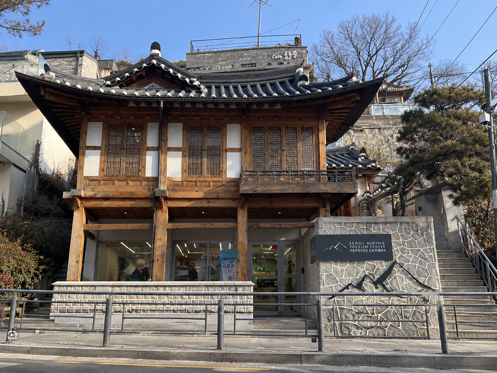
4. Bugaksan — History, Stairs and the Seoul City Wall
Difficulty: Moderate
Time needed: About 3 hours
Distance: 4.7 km
Nearest subway: Gyeongbokgung Station, Line 3, then bus 1020, 7022, or 7212
Trailhead access: Get off at Jahamun Pass/Yoon Dong-ju Hill and walk to Changuimun
Best for: Travelers who prefer history, walls, and urban views to wild terrain
Best season: Spring or autumn
Gear: Sneakers with good grip in dry weather; trail shoes are better after rain
Main drawback: The staircase from Changuimun to Baegakmaru is a real climb
Follow the Seoul City Wall from Changuimun to the 342-meter Baegakmaru summit, then continue past Cheongundae, Sukjeongmun, and Waryong Park toward Hyehwamun.
It is a clear point-to-point route.
The first climb is steep and stair-heavy, so Bugaksan is not as gentle as Achasan or Ansan.
The payoff is different from Bukhansan.
Here, the appeal is walking along the historic defensive ridge above Seoul’s palace districts and older neighborhoods.
Older guides may mention limited daytime entry windows or passport checks.
The current Seoul City Wall information lists the Baegak section as open 24 hours, 365 days, with self-entry and no identification requirement.
Access rules can change, though, so recheck the official site before visiting.
And even if the route is technically open after dark, finishing an unfamiliar first hike in daylight is still the more sensible plan.
5. Ansan — The Low-Stress Forest Option
Difficulty: Easy
Time needed: About 2.5–3 hours for the loop with an optional summit detour
Distance: About 7 km for the full Jarak-gil loop
Nearest subway: Dongnimmun or Muakjae Station, Line 3
Trailhead access: Walk through Independence Park from Dongnimmun, or approach from Muakjae
Best for: Forest shade, flexible plans, and travelers who do not need a dramatic summit
Best season: Spring through autumn
Gear: Regular walking shoes or sneakers in dry weather
Main drawback: The gentler loop feels more like a long forest walk than a mountain climb
Ansan Jarak-gil is a roughly 7 km circular forest path.
Much of it follows wooden decking or broad compacted ground, making this one of the easiest routes in the guide to shorten or adjust.
or a stronger viewpoint, add the climb toward the beacon mound near the 296-meter top.
Those extra stairs turn a nearly barrier-free forest walk into something that feels more like a hike, so skip that detour if you want the gentlest possible version.
The tree cover can also make Ansan more comfortable than exposed Inwangsan on warm days. Humidity still counts.
Views appear through the forest toward Inwangsan and Namsan rather than from one dramatic open granite ridge.
Choose Ansan when the hike is part of your Seoul day—not the entire reason for it.
Do You Need Hiking Boots for Seoul Hikes?
Sneakers are usually enough in dry weather: Achasan, Ansan Jarak-gil, and Bugaksan for walkers comfortable on stairs.
Trail shoes are recommended: Inwangsan and Bukhansan’s Samobawi–Bibong route.
Hiking boots become much more useful: Harder Bukhansan or Gwanaksan summit routes, especially in cold, wet, or unstable conditions.
The important thing is grip, not whether the shoe looks like “hiking gear.”
Smooth lifestyle sneakers are a bad trade on wet granite even if the route is short.
In winter, snow and ice can turn an easy route into a very different hike.
Use appropriate traction when conditions require it.
What Hiking in Seoul Is Actually Like
Trails are generally signed, but junctions can still be confusing when you are relying only on English.
Save the Korean mountain and trailhead names in Naver Map and screenshot the route before starting.
Weekend mornings can be busy.
There is no hiking dress code.
Water, grip, sun protection, weather, and enough daylight matter much more than looking like you just walked out of a Korean hiking commercial.
Pajeon, noodles, soup, and other meals are common around larger trail entrances.
Plan your meal for after the hike rather than adding anything that affects balance or judgment before the descent.
Best Time of Year to Hike in Seoul
Spring: Mild overall, but check rain, fine dust, and trail surfaces.
Summer: Heat and humidity can make a short route feel much longer. Start early and carry water.
Autumn: Often the most comfortable season, but foliage weekends can be extremely busy.
Winter: Clear views are possible, but snow and ice can completely change the difficulty.
Summer Hiking: Do Not Underestimate Seoul Heat
Inwangsan has exposed upper rock.
Ansan has much more tree cover.
Check heat alerts, start early, carry enough water, and turn around if the conditions are clearly worse than the plan you prepared for.
Winter Hiking: Ice Changes Everything
The official Inwangsan information advises winter traction on rocky sections.
If you do not have appropriate footwear, rent gear, choose a lower-risk route such as Ansan Jarak-gil, or simply wait for a dry day.
Should You Hike After Rain?
Wet granite is not a great introduction to Seoul hiking.
Be especially cautious on Inwangsan and Bukhansan.
Stairs and wooden decking can also become slippery.
If rain continues, visibility is poor, or an official closure is posted, change the plan.
The mountain will still be there tomorrow.
Do Not Start Too Late
Check sunset for your travel date and build in a daylight buffer.
Unfamiliar junctions become much harder when you cannot see them properly.
A summit-at-sunset photo may look good.
Searching for the correct descent after dark is less photogenic.
Getting to Seoul Hiking Trails Without a Car
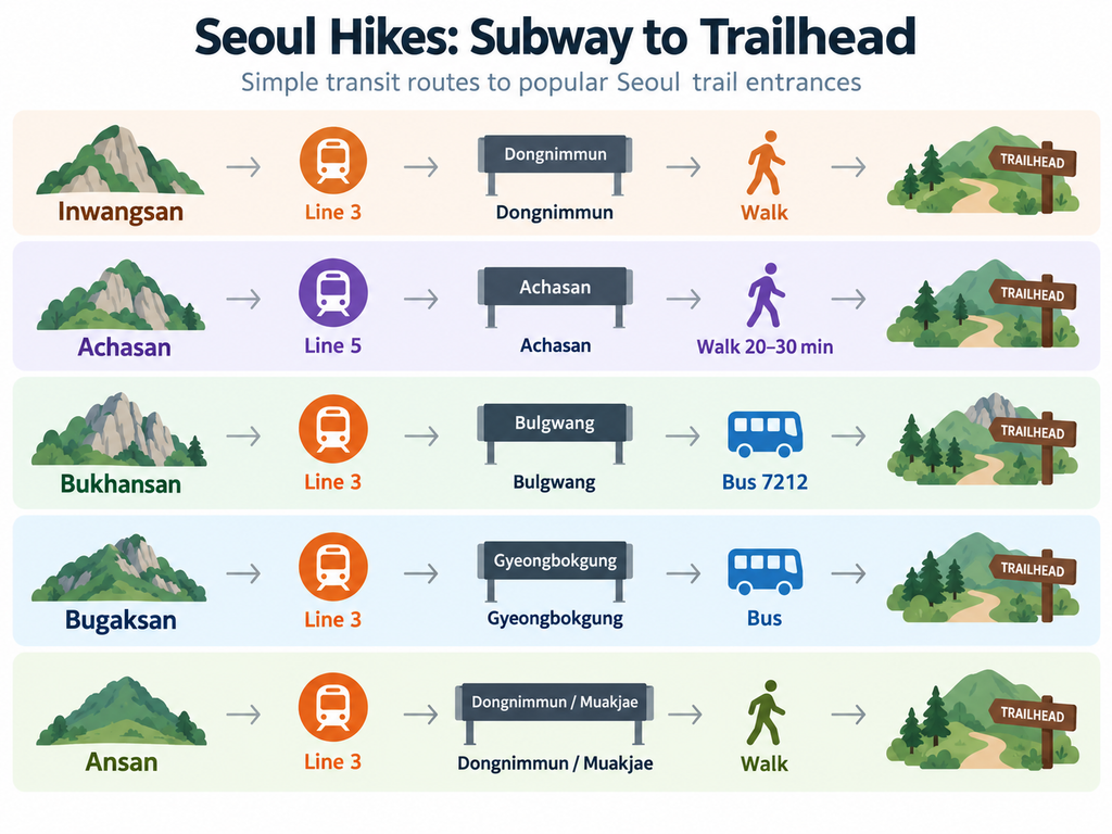
- Inwangsan: Line 3 to Dongnimmun, then walk from Exit 2.
- Achasan: Line 5 to Achasan, then walk uphill from Exit 2.
- Bukhansan: Line 3 to Bulgwang, then bus 7212 toward Gugi.
- Bugaksan: Line 3 to Gyeongbokgung, then bus 1020, 7022, or 7212 to Jahamun Pass.
- Ansan: Line 3 to Dongnimmun or Muakjae, then walk.
Use live Korean map directions because bus stops, road work, detours, and the most convenient entrance can change.
Which Seoul Hike Fits Your Trip?
Never hiked before: Achasan
Only have around two hours: Inwangsan, with a shorter return route
Have half a day: All five work; Bukhansan is best for active travelers
Want skyline photos: Inwangsan
Want a real mountain: Bukhansan
Interested in Seoul history: Bugaksan
Traveling solo: Achasan, Inwangsan, or Ansan during daylight
Have no hiking gear: Achasan or Ansan
Visiting in summer: Ansan early in the day
Visiting in winter: Decide based on actual ice and trail conditions
Is Hiking Worth It on a Short Seoul Trip?
Two days in Seoul: Probably skip it unless hiking is one of your main reasons for visiting.
Palaces, neighborhoods, markets, and an evening area can already fill two days very quickly.
Three days: A short Inwangsan or Achasan hike can fit nicely into one morning.
This works especially well if you want a break from indoor attractions and shopping.
Five days or more: A half-day hike becomes much easier to justify.
Bukhansan or Bugaksan also makes more sense because the transport and trail time are not competing as heavily with first-trip essentials.
Example Half-Day Plan: Inwangsan
8:00 a.m. — Leave your hotel after checking weather, air quality, and current trail notices.
8:30 a.m. — Arrive at Dongnimmun Station. Buy water and use the restroom.
8:45 a.m. — Walk toward Inwangsa Temple and the Seonbawi trail.
9:00 a.m. — Start climbing.
10:10 a.m. — Reach the summit area and stop for photos without blocking the trail.
10:30 a.m. — Begin descending toward Changuimun and Yoon Dong-ju Hill.
11:30 a.m. — Finish the route and take a bus downhill.
12:00–12:30 p.m. — Eat lunch around Seochon or Buam-dong.
Add extra time for crowds, navigation, heat, or a slower hiking pace.
Basic Hiking Safety in Seoul
- Check the forecast, air quality, and official closure notices.
- Carry water; do not assume summit facilities exist.
- Wear shoes suitable for the surface and season.
- Stay on marked trails.
- Keep enough daylight for the descent.
- Save the route and Korean trailhead name offline.
- In an emergency, call 119 and share the nearest trail marker or map location.
These mountains are convenient.
Weather and footing still get the final vote.
FAQ
What is the easiest hike in Seoul for a first-time visitor?
Achasan is the easiest all-round mountain in this guide, with a manageable climb and no sustained technical section.
Ansan Jarak-gil is even gentler if you prefer a forest walk rather than a summit-focused hike.
Is Inwangsan easy for beginners?
It can suit a fit beginner in dry weather.
Expect stone stairs, exposed granite, and narrower upper sections.
Allow around two to two and a half hours for the recommended route.
Can tourists hike Bukhansan without a guide?
Yes.
Choose a marked route that matches your experience and check current national-park information before starting.
The Samobawi–Bibong route is moderate.
Baegundae is a significantly harder outing and should not be treated as the default beginner route.
Do I need hiking boots in Seoul?
Not for every hike.
Grippy sneakers are normally sufficient for Achasan and Ansan in dry weather.
Trail shoes are a better choice for Inwangsan and Bukhansan.
Snow or ice may require much more serious traction.
Can I reach these Seoul hiking trails by subway?
Yes.
Bukhansan and Bugaksan generally need a short bus connection.
The other routes use subway plus walking.
Use live Korean map directions for the final approach.
Is hiking in Seoul safe for solo travelers?
Popular routes often have many solo hikers during daylight hours.
Keep your phone charged, remain on marked trails, save the route, and avoid unfamiliar descents after dark.
What is the best Seoul hike for city views?
Inwangsan offers the strongest central-Seoul view for the amount of time required.
Bugaksan adds Seoul City Wall scenery, while Achasan is better for Han River and eastern-Seoul views.
Can tourists rent hiking gear in Seoul?
Yes.
Seoul Hiking Tourism Centers around Bukhansan, Bugaksan, and Gwanaksan offer equipment rental.
Check the specific branch, current hours, item availability, and live rental price before visiting.
Sources & Last Updated
Key information in this guide was checked against:
- Seoul Hiking Tourism Center
- Seoul City Wall
- Gwangjin-gu Achasan information
- Seoul Danurim
- Korea National Park Service weather service
Research Checked: September 20, 2026
Last Updated: September 28, 2026
Trail conditions, closures, operating hours, and weather can change.
Check official trail information and the forecast shortly before hiking.